Kato Mivule | March 1st 2010
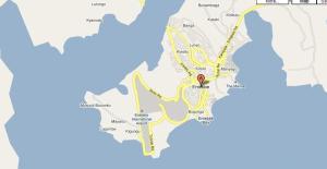
An interesting development as Ugandan maps become digitized. Google is surely becoming a force in the Information Technology Revolution in Africa…
Uganda: Google Launches Maps | AllAfrica| Sylvia Nankya |24 February 2010
Kampala — Detailed maps of Kampala and Entebbe are now accessible on Google Maps through any web browser. The maps can also be accessed on data enabled mobile handsets. They come with both a satellite and a terrain view of the cities. Kenya and South Africa were the first beneficiaries of the Project which has now extended to 29 cities across Africa. “Google Maps isn’t just a searchable digitised maps helping you to find a local place, service or product – it is about making information with a geographical dimension available to everyone” Rachel Payne Country Manager Google Uganda said recently. Google believes that more accurate local information can greatly improve the breadth of information available about a given area and in turn can help efforts to bolster tourism and business investment. Businesses can also benefitfrom the Street View technology by embedding Google maps directly into their site for free, helping them to promote a chain of hotels or raise awareness about a local library or restaurant, Payne said. She added that the service will give tourists a taste of the variety that Uganda offers, and a chance to research their holidays in advance. The map data includes a substantial amount of user generated content provided via Google Map Maker. The Map Maker allows users to locate, draw, label and provide attributes for local map features, such as roads, parks, or rivers, turning local users into “citizen cartographers.” Payne allays fears that the maps could pose a security threat to the cities. “The Information we are using on Google is approved and available to every citizen, she said.

No comments:
Post a Comment